
Queen Anne’s Well, Chalvey
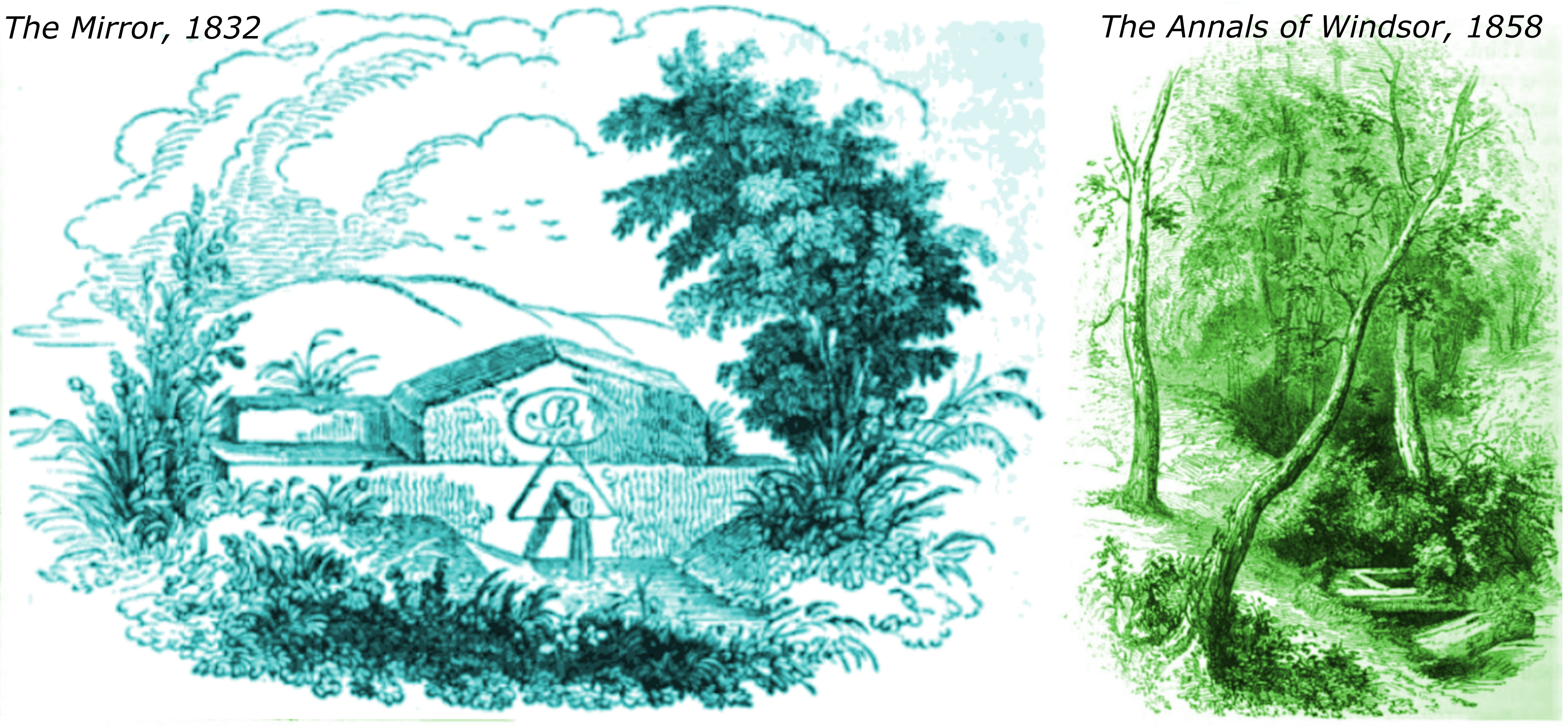
Queen Anne’s Well is said to have first been used to supply drinking water to the monarch at Windsor Castle at least 300 years ago. It wasn’t a well in the sense generally recognised today, but actually a spring. The earliest account known to us is in the 1832 edition of The Mirror [1] in which it was described as a sequestered spot of sylvan shade whence rises a spring of limpid crystal in gentle, yet ceaseless streams which convey health to the sick and solace to the swain. There is a charming woodcut accompanying the article. A later article in Tighe & Davis’s Annals of Windsor (1858) [2] also contains a similarly picturesque looking woodcut although the two depictions have no definite features in common. According to both The Mirror and The Annals of Windsor, it was said that Queen Anne had water from the spring taken to Windsor for her use. Queen Anne (1665–1714) was the last of the Stuart monarchs. She was depicted by Olivia Coleman in the movie The Favourite in 2019. Although this was mainly filmed at Hatfield house, during her reign Queen Anne came to reside principally at Windsor. According to The Mirror, Queen Anne was responsible for the placement of stonework over the spring along with a spout which fed the water into a trough.
Both accounts go on to say that the spring was also favoured by Queen Charlotte and she had the water transported daily by pail to Windsor for many years. Charlotte of Mecklenburg-Strelitz (1744-1818) was the wife of George III (who is mainly remembered for his recurrent, and eventually permanent state of mental illness). In 1785 a headstone was placed over the spring bearing the King’s monogram and the year.
By 1858 the spring had fallen into disuse. It was on private land and villagers had been prevented from collecting the water by stopping up the path which led to it. It seems that by the early 20th century, local memories had become vague as to where Queen Anne’s Well had been located. In recent decades, Queen Anne’s Well is most usually identified as a spring flowing into the brook that exits Salt Hill park under the Bath Road. On the section of Ordnance Survey Map of 1900 shown below the spring is marked with an arrow.
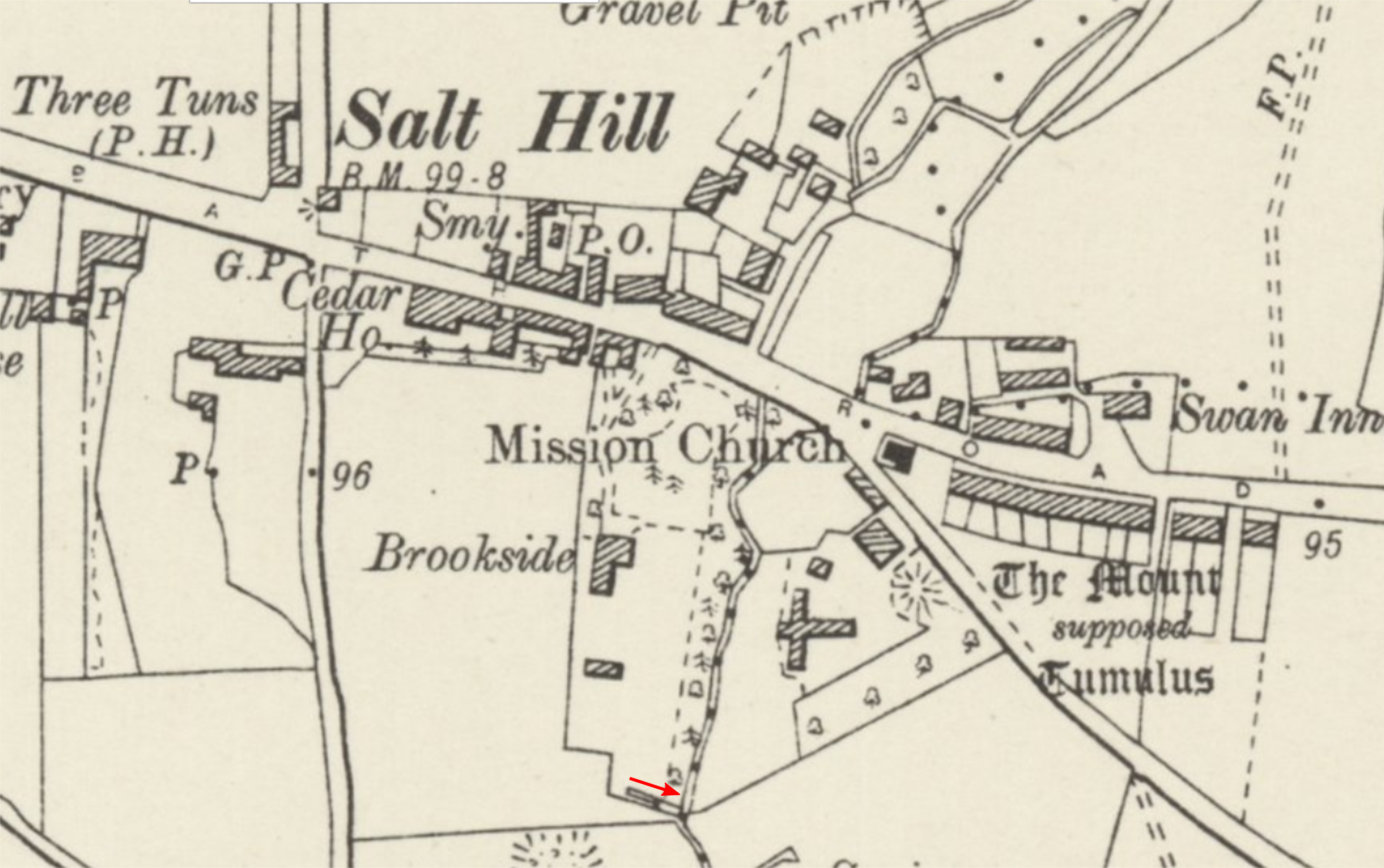
At this time the spring was in the south east corner of extensive grounds belonging to a house called Brookside. The grounds stretched north from where Seymour Road is today up to the Bath Road. The spring was a stone’s throw away from Chalvey’s ancient enigma – the Montem Mound. Debate has ranged widely as to its age and purpose, from prehistoric barrow to a Norman bailey. In 2016, core samples taken from the mound were carbon isotope dated to between 450 and 700 AD, vindicating the minority who thought that the earth-working could be Anglo-Saxon. If it is a burial mound, then its large size could indicate that it was created for a high status individual such as a sub-king. The website Strange Britain [3] has an interesting quotation from the historian Michael HH Bailey in 1970 “The spring is near an artificial mound, Montem, and was by a river crossing; in this case, of an old branch of the Thames dammed off in the 13th century. Up and down the middle and lower Thames these three things in association – a hill or hillock, a holy well and a ford – are usually connected with the name Anne, either Saint or Queen. The lady in question is the pagan British deity Sanct Anner, the Holy One of the Heifer. The name of Anna was held by the Priestess of Dionysus in Rome as late as 3 BC”. It isn’t hard to imagine how over many decades the names St. Anne and Queen Charlotte could have mingled to produce the name of Queen Anne’s Well. But if this is so, Queen Anne’s actual use of the spring would have to be either a just legend or a coincidence.
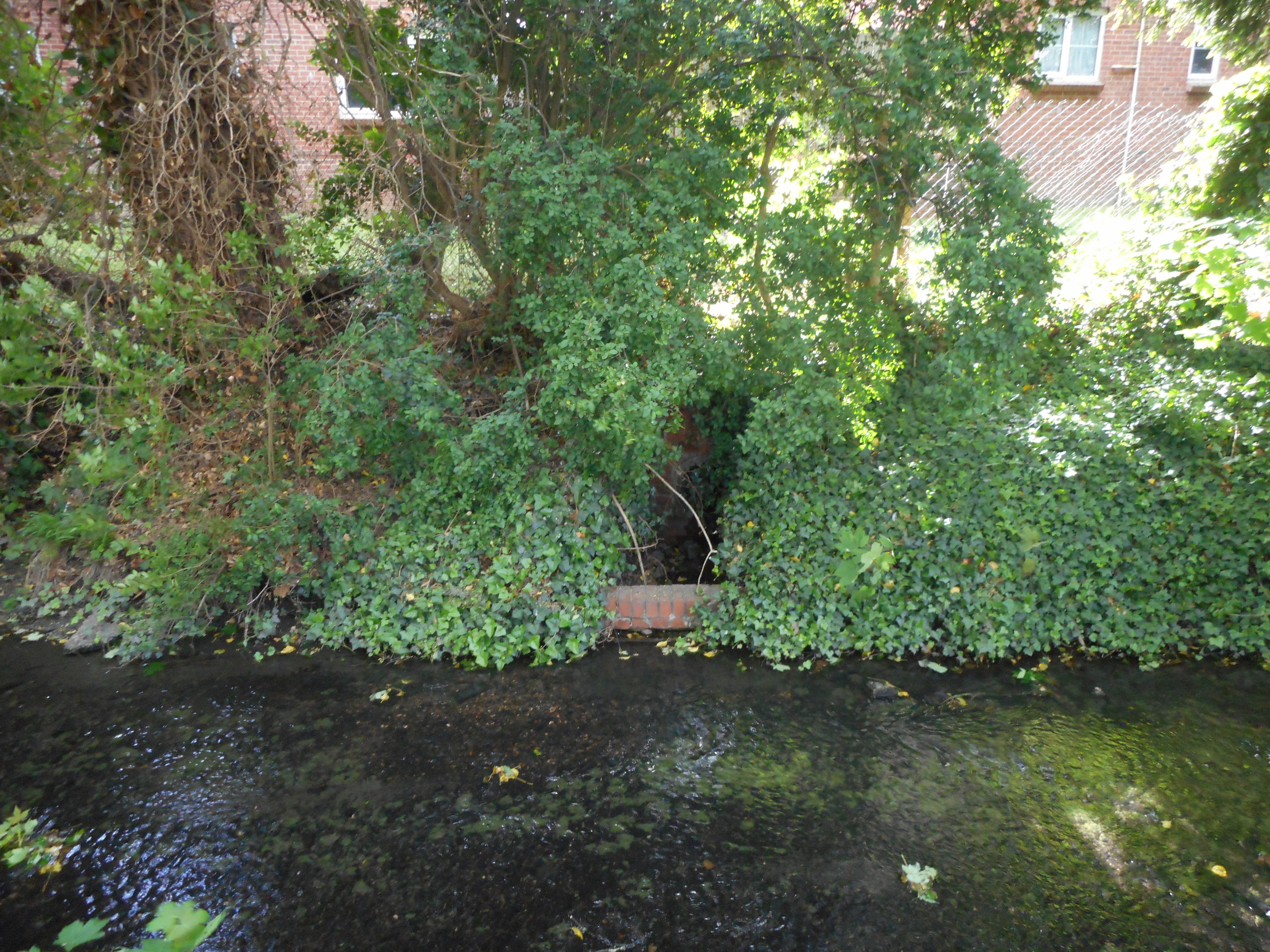
Michael Bayley’s assertion that the Montem was at the time of its construction by the bank a full river leads us to an intriguing speculation. Perhaps the mound conceals a ship burial as per the barrow at Sutton Hoo which is of contemporary age. It would also explain how Edward II could have been carried by barge from London all the way to Cippenham. In our researches, we haven’t been able to find any historical support for a branch of the Thames getting dammed, as yet. On the fate of the spring, Michael Bailey asserted that some stonework from the spring went to make a horse trough and the rest was broken up to form a lily pond in the 1920s. Locals reported that the lily pond was covered over with rubble during the building of an outdoor swimming pool at Montem. Today there is nothing left of this spring, the general area where the spring was situated is now tarmacked over and built on. The only trace to be seen is a drain from the spring (now dry) in the bank the brook.
It would be sad if that was the end of the story of Queen Anne’s Well, but fortunately it isn’t. In her History of Slough [4], Maxwell Fraser wrote how Queen Anne’s Well gives an admirable example of the danger of relying on local ‘tradition’ or old people’s ‘recollections’ as they are at times misleading and wherever possible should be checked from other sources. Whereas there were natives of Chalvey in the early 20th Century who said that that Queen Anne’s Well was in the garden of Brookside, there were others that claimed it was a spring which fed watercress beds south of Cippenham Lane. Although the consensus of local belief today still seems to be that the spring was located as previously described, it certainly seemed that belief that the site was south of Cippenham Lane was strong in the early 20th Century. In an article from The Advertiser and Gazette in 1938 [3] the writer describes how she wasn’t able to actually visit the spring as it was on private property, but was able to view it looking due south from “the old quarry”. The quarry corresponds to the location of a gravel pit marked on the 1932 Ordnance Survey, south of Cippenham Lane and just north of the position where two watercress beds are shown on the map. The writer also stated that the spring was due west of Queen Anne’s cottages. Although demolished long ago, these cottages were located just off Church Street on the west side of Chalvey. According to the article, the spring fed two adjacent watercress beds that had been dug out in the 19th Century but now gave the appearance of a pretty pond.
The confirming factor that the real spring was to the west of Chalvey is that it is annotated as such on the 1840 tithe map of the parish of Farnham Royal [6]. The tithe map shows a plot of land belonging to a Rev. Henry Wakeham and occupied by a John Mason esquire. A spring is shown on the plot and in the accompanying key the plot is named as “Queen Anne’s spring”. The State of Cultivation is recorded as woodland. Earlier than any known reference and being the only precisely described location of Queen Anne’s Well from the 19th Century makes this impossible to ignore.
We downloaded an image of this tithe map, and to ensure identification of the correct location of the spring, we were easily able to transfer the position onto a current map even though the tithe map is not precisely scaled. The location corresponds to watercress beds marked on the current map which are (almost incredibly) still in existence today, tucked into a parcel of land bordered on the north by Keel Drive and to the south by allotments. The site can be reached from a track which runs up at the side of the allotments. The outflow from the spring runs down alongside the track into the nearby Chalvey brook. The rate of flow from the spring probably amounts to at least 10 gallons per minute. The top of the track opens into a pleasant wooded dell containing the watercress beds which have a steep hillock in between them. The watercress beds and their surrounds are heavily overgrown. The mouth of the spring isn’t evident and if it is above the water level in the cress beds it is probably well concealed by vegetation. Woodland of around 2 acres stretches to the west between the allotments and the rear gardens of Keel Drive. It is difficult to walk very far into the woodland as thick clumps of brambles grow between the trees. Unfortunately there is quite a fair amount of rubbish on the site. Bottles, cans, wrappers etc. are strewn around the watercress beds. Further in, there is a large tip of items such as freezers, mattresses etc..
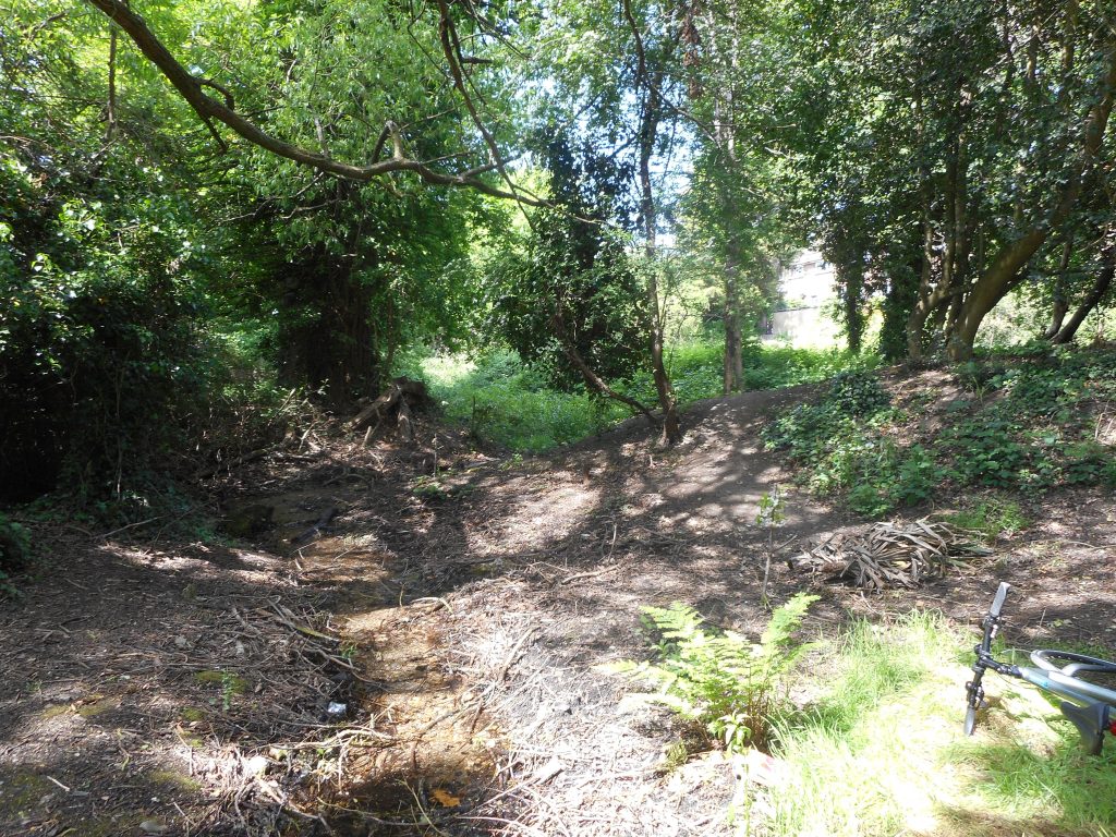
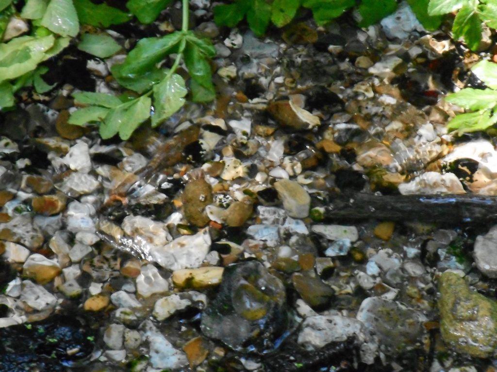
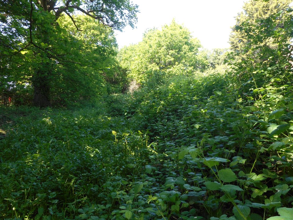
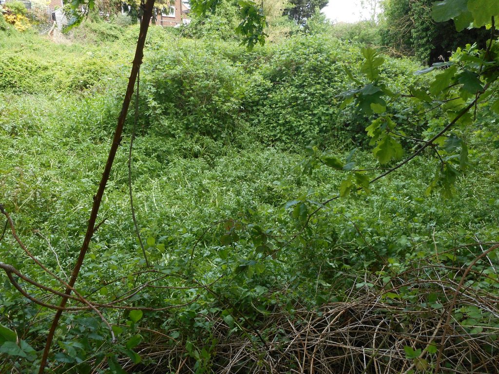
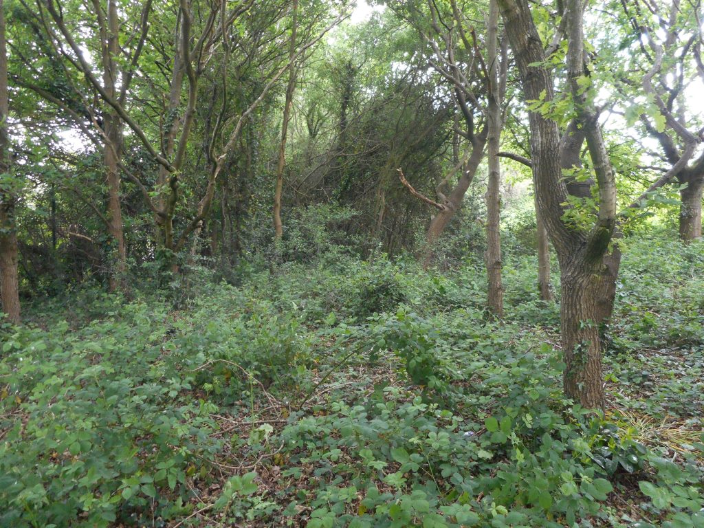
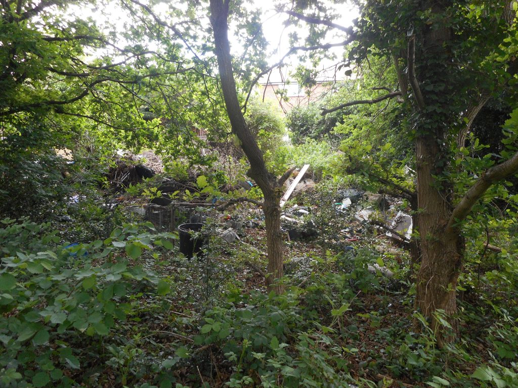
Images of the site of Queen Anne’s Spring as it is today
Unfortunately, nothing is known on the motivations of the Queens of England in having their water transported from this particular spring (over a distance of 3 miles). Of course spring water is very safe to drink but the dangers of drinking water from other sources weren’t fully recognised until the late 19th Century. The water may have been favoured simply a matter of taste and appearance. Spring water from this area is highly filtered and is clear to the eye as a result of having passed through many miles subterranean gravel terracing before reaching the surface. The water may also have a tastable mineral content. According to a letter published in The Slough Observer in 1925, the spring was said to contain a small quantity of Lithia (lithium salts).
The spring may well have had a reputation for healing. Springs have often been associated with healing and the miraculous. Like may other springs in the British Isles, it may have once been venerated as holy. It is interesting to note that the spring is only a half mile away from the supposed site of the Saxon royal palace dating from the Heptarchy. It is an intriguing thought that the spring may been known and revered in much earlier times.
Looking to the future
It would be a tragedy if this wonderful site, after surviving against the odds to the present day should in the end fall victim to the ever more intense demand for housing in the Slough area. If the site happened to be in the hands of private ownership then perhaps it would be impossible to do anything to prevent this from happening. Fortunately, however, when we checked, we found the land is actually in the possession of Slough Borough Council.
The creators of cippenham.org believe that this important and historic site should be protected. It could be transformed into a beautiful nature reserve or community garden, run and maintained by volunteers for the benefit and enjoyment of the local population. We think it would be a wonderful thing to be able to organise
- Clearing all the rubbish from the site
- Managing the woodland and vegetation
- Laying pathways.
- Installation of new stonework, spout and trough at the spring
Anyone who is interested in joining a group or forum to help make this happen can express their interest to us by sending an email to the address queenanneproject ‘at’ cippenham.org.
We look forward to hearing from you.
References
1 The Mirror of Literature, Amusement, and Instruction, Volume 19, Pub 1832. Page 248. Available online
2 Annals of Windsor, by R.R. Tighe and J.E. Davis, Volume 2, Pub 1858. Pages 495-6. Available online
3 Strange Britain Website. See www.strangebritain.co.uk/holywells/anne.html. At the time of writing this website was down, but the contents may, however, be accessed via a web archive service.
4 The History of Slough by Maxwell Fraser, 1980 edition, Chapter 5: The Manor of Chalvey. Pages 36-37. Available online
5 Two Queen Wells, by Sylvia Skyring. Article in the Advertiser and Gazette, January 7th, 1938. Can be accessed via British Newspaper Archive (at a cost).
6 Tithe Map of Farnham Royal. 1840, signed G H Whalley. The Bodleian Libray, Oxford. This can be viewed online through “The Genealogist” website , but only with a paid subscription.
7 ‘Chalvey Spa’ – letter to The Slough Observer, 8 April 1925, signed R.B. (possibly Richard Bentley) Can be accessed online by searching here
Related Links
In search of Queen Anne’s Well, Chalvey, Slough – interesting blog post on the subject of Queen Anne’s Well, Chalvey.
Images reproduced with the permission of the National Library of Scotland
Map Images Website https://maps.nls.uk/index.html


I would love to keep this area as a nature reserve when I first came to Chalvey in 1958 and after, Montem Park was lovely -and will do all I can to keep it from Being built on. I would love to be part of this project to restore Queen Anne’s well.
I’d love to help! Email me and I’d be keen to make a plan, before they develop it or something hideous!
I was born in Cippenham Lane in 1949. As a youth I spent many hours with my friends in Montem park during the early 1960s.
I was told that Queen Annes Well water was transported to Windsor castle. The water was favoured by the Queen for the sole purpose of bathing her eyes. No mention was made of anyone drinking the water.
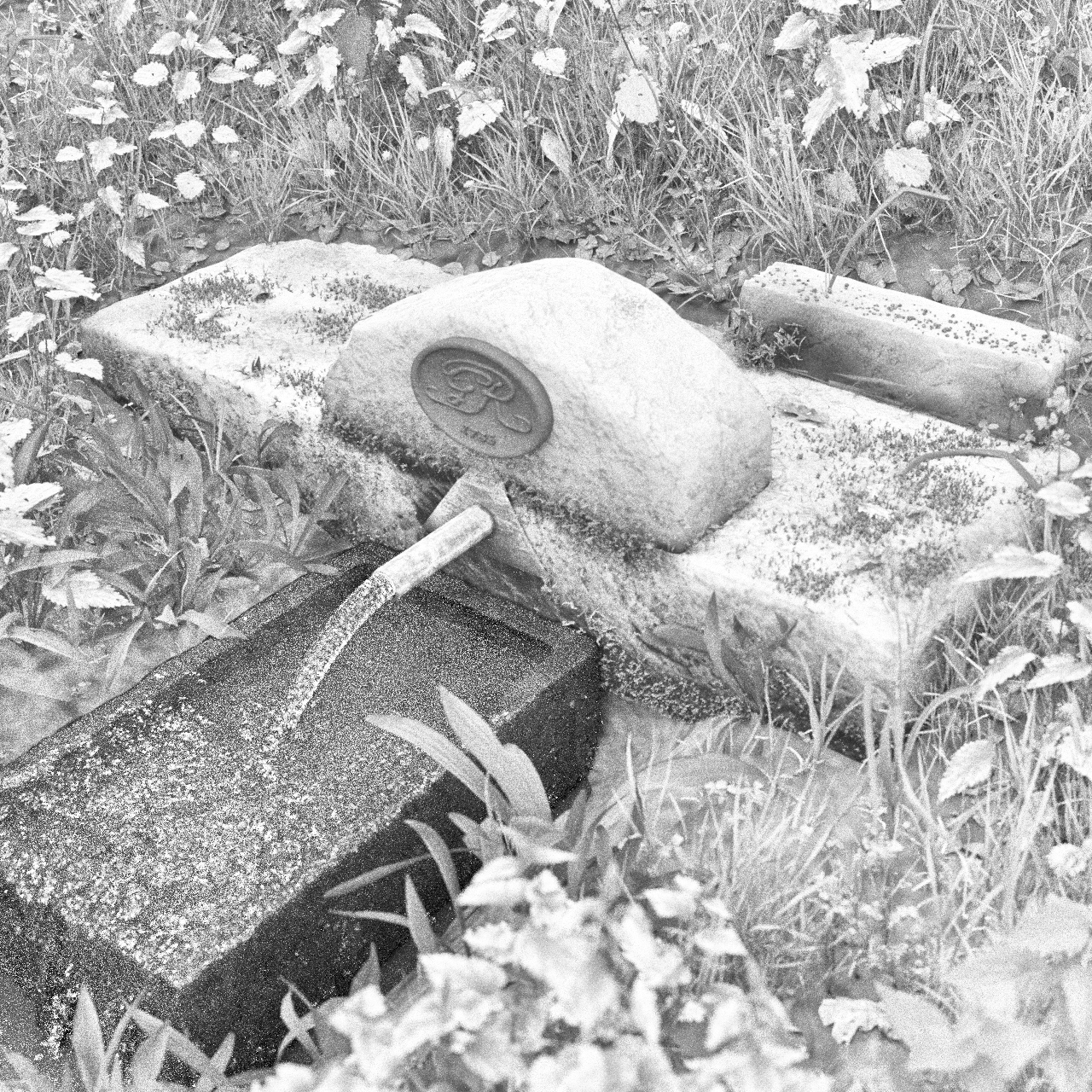
I never saw the spring because the grounds in which it was supposed to be situated had a few small gravestones in the corner near Chalvey brook. The stones inscribed with single names were certainly where dogs were buried.
It was too creepy to explore.
There were cress beds where we kept our horses between Keel Drive and Chalvey Grove. The water was top quality. Handy for the horses and for us on a hot day.
I believe the confusion is because there were probably TWO springs. I remember the one in Montem Pleasure Grounds (as they used to be called). There used to be a dry circular pond / lido there with a pebble base, and just uphill from it, there was a spring under a clump of bushes. These were both located under what is currently the Montem Car Park. When they were building the now demolished sports centre, they dumped a load of sand / gravel near this pond and this appeared to block some kind of drainage as part of it over-spilled into the pond which then filled up with the water from the spring….we used to build rafts and play in the pool..