
The Cippenham V1
In World War 2, Cippenham escaped relatively lightly from German bombing. At around 8:40 AM on 23 August 1944, however, a V1 flying bomb (doodlebug) fell from the sky and exploded near to the boundary of the village green.
A revolutionary weapon
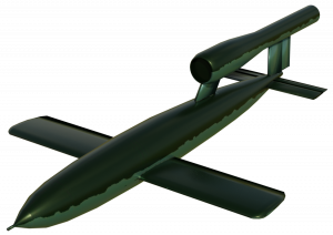 The V1 was powered by a pulse-jet which gave it its distinctive sound which was likened to an unsilenced single-cylinder motorcycle. Its payload was 850 kg of explosive. The short-lived Nazi doodlebug campaign commenced 13 June 1944 and around 100 doodlebugs were launched daily targeting London. When in flight, the heading was controlled by a compass and the distance to the target was estimated from the revolutions of a small propeller driven by the airflow. As such, the weapon’s accuracy was limited by the predictability of the weather. It was rare, however, for a V1 to have travelled as far west as Cippenham. Although the doodlebug was fast, travelling up to 400 mph, the flight profile of a straight line at fixed altitude was a significant vulnerability and effective countermeasures were developed rapidly. By the time of the Cippenham V1 around 80% were being destroyed by barrage balloons, anti-aircraft artillery, and most successfully of all, by fighter interception. Little more than a month after the Cippenham V1 the threat from V1s ended altogether as advancing allied troops overran the launch sites on the French coast.
The launch
Early in the morning of 23 August, a Luftwaffe battery situated in Pas de Calais set up to launch a salvo of the missiles. Each was projected into the air from a long ramp by steam catapult at intervals of a few minutes from each other. At least six missiles were launched over the space of an hour, three of which penetrated the coastal defences. At 7:59 AM one V1 fell and exploded in Cippenham.
The place of impact

BC4 for Cippenham V1
The Cippenham V1 impacted into farmer Gregory’s Orchard, north of the green. The main source of information comes from the BC4 (Bomb Census 4) form which was completed by the Air Raid Precautions (ARP) for every bombing incident. All BC4s are stored at The National Archives. Along with the description of the location of the point of impact, the BC4 also contains a map reference MR114/387999. These coordinates refer to the a secret grid system applied to standard Ordnance Survey maps called the ‘purple grid’ because it was originally overprinted in purple ink. In the inset image below, the red square represents the reference given on the wartime map number 114. It ties down the point of impact to an area 100 x 100 metres. The map is on a scale of 1/63360 which is not very detailed. Neither the village green boundary nor Gregory’s orchard, as referred to on the BC4, are marked on the map although some features are easily recognisable such as Elmshott Lane, Lower Cippenham Lane, and the millstream.

Estimated location of V1 explosion on 1938 OS map. Map 114 reference 387999 shown inset
To get a better sense of the impact location, the reference position has was approximated onto the 1932-1938 Ordnance Survey county series map which has a scale of 1/2500. The BC4 states point of impact was 150 yards North of Cippenham Common Boundary. This is represented by the horizontal green line on the map and it is above both the map reference square and the north boundary of the orchard. The two clay-brick (c.b.) houses referred to on the BC4 are still standing today. The BC4 states the impact point was 350 feet radius of 350 feet from these houses. This is represent by the purple arc, which also falls outside the the reference square. It seems likely that whoever filled out the BC4 overestimated the distances. Taking all factors into account, the turquoise x is best our estimate as to where the V1 struck. This puts the point of impact within Frenchum Gardens.
The damage
Fortunately, there were no fatalities although seven people were injured. The nearest two houses to the explosion still stand today. One is a detached house called the Greenway. The other is semi-detached. The Greenway bore the brunt of the blast and suffered severe structural damage including the blowing in of the rear wall. A mother and her four-year-old boy boy were in the house at the time. The boy sustained a cut to the head which was bandaged at a local first-aid station. The mother was unhurt.
An additional 150 houses suffered superficial glass, tile, and plaster damage – a surprisingly large number considering the sparseness of housing in Cippenham at the time. The crater left by the explosion was 18′ by 1′ deep.
Afterwards
The Greenway and the house next to it had been built by a local builder who lived in Lower Cippenham Lane in a house next to the pond. He was enlisted to repair the damage to the houses
It is been said that in the final days of the war, German Prisoner-of-War labour was employed in the building of the British Iron and Steel Federation (BISF) houses of Frenchum Gardens, in which case it is ironic that they would have probably had the task of filling in the explosion crater.
It is possible that some identifiable metal fragments may still lurk beneath the lawns and the flower beds of Frenchum Gardens which could be found with a metal detector.
Related items:
Thanks to Dave Hill and John Lincoln whose earlier comments led to improvement of this article.
Images reproduced with the permission of the National Library of Scotland Map Images Website https://maps.nls.uk/index.html


I lived in the bungalow on the corner of Stow road and Bowyer drive in the 80s and to get the mortgage approved I had to have a dip taken out of the roof ,I was told that the roof slates were damaged by a bomb and replaced by heavier tiles without extra support ?
The damage could well have been from the V1, but could also have been from another bombing that occurred around Bower Way in October 1940.
I suppose the “steel houses” in Bowyer Drive & Frenchum Gdns were not built in 1944, I was only 1 then and can’t remember them till I was about 7 I suppose. Didn’t another bomb fall on some OAP bungalows off Bower Way? My dad said chap used to flood adjacent bit of Green in winter so it froze and they skated on it, he went to school next to Tin Tabernacle, it was a pig farm when I was a kid!
About ten years ago I had an internet ‘conversation’ with a man who was in one of the semi-detached houses which were closest to the explosion. He was however only five years old at the time. He said that early in the morning the bomb landed in the meadow to the north of the house and that the back walls of the house were blown in. No one was injured. The houses had been built by a local builder and were soon repaired. These houses are presumably the older houses now in Roxwell Close.
Given the date it is almost certain that this V1 was launched from an aeroplane in the Thames estuary and aimed at London. Probably the ranging device failed and it flew on until it ran out of fuel.
Strange Irony. It landed where Frenchum Gardens was later built. The BISF houses in Cippenham were built by German prisoners of war so presumably they had to fill in the crater.
Thank you for your very interesting comments.
I had previously come across the notion that the Cippenham V1 was air launched, based on it being seen to overfly Chalvey recreation ground and must therefore have originated from an easterly direction.
I’ve just done a little digging on this. It seems our Cippenham V1 was part of a salvo launch as there are records of at least 5 others over the space of an hour.
7:58 New Southgate, exploded
7:59 Cippenham, exploded.
8:20 Acrise (inland from Folkestone), shot down by AA
8:20 Elham (inland from Folkestone/Dover), shot down by fighter
8:32 Chiswick, exploded
9:00 Lyminge (near Folkestone) shot down by AA
If you draw a line from Cippenham through the middle of the three interceptions you end up at Pas de Calais. According to Peter J C Smith’s book “Air-launched Doodlebugs. The Forgotten Campaign” there were no V1 air-launches after 22 August until 29 August. During this period the Pas de Calais batteries were still in action. The last V1 fired from Pas de Calais was on 1 September.
Correction. The house was actually the detached one still accessed from Lower Cippenham Lane. The house can be seen clearly on this Francis Frith photo of Millstream Lane. https://www.francisfrith.com/cippenham/cippenham-the-green-1950_c442004
Also I should have said nobody was ‘seriously injured’. The man was actually hit by some flying debris and had to go and have his head bandaged up.
dis lyk B4 or AFTA dey bilt da skatepark?
You mean Stowe Road and Bower Way?
I lived in Warner Close when we were kids in the 80’s we used to play in Greg’s farm field – there was indeed a crater in the middle of it and it was known then as the V1 bomb crater.
I addition there was all kinds of military junk left along the edge of the field, including amphibious vehicles, airplane parts, munitions boxes, rusting army trucks.
There was also a building with a caved in roof, which legend had it was where a hurricane had crashed (wheels and parts still lay near by)
The hole in the field on the south side of the green wasn’t a crater of any sort. There was a manhole cover at the bottom giving access to the pipeline which ran to the sewage works in Wood Lane.
There was an aero tyre in the yard but it was very large and must have come from a multi-engine aircraft. There were no other aircraft parts there. No aeroplane ever crashed there.
My Aunt Jo told me that she was working in a (jam?)factory on the Trading Estate on the north side of the railway line when the V1 fell on Cippenham.
She,my mother and her parents lived at 98 Cippenham lane with 2 children when the bomb fell. Aunt Jo said all the girls ran out of the factory and up the railway bridge. She said she could see smoke but was in such panic she couldn’t work out if her house had been hit. Then she saw a television ariel on the roof of her house. My Grandfather had (possibly)the first TV in Cippenham just before the war. The service was stopped but the ariel was still on the roof.The TV only had about 3 lines and thought it was rubbish so he never bought another . My mum said the bomb had fallen on the corner of the village green. I lived in Cippenham from birth to age 20 in 1969 but never saw any sign of the event.
it did fall on corner of green in Challens garden, now Roebuck close.